 Old Web
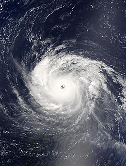
Hurricane Isabel

Other wikisHurricane Isabel was the strongest Atlantic hurricane since Mitch, the deadliest, costliest, and most intense hurricane in the 2003 Atlantic hurricane season. The ninth named storm, fifth hurricane, and second major hurricane of the season, Isabel formed near the Cape Verde Islands from a tropical wave on September 6, in the tropical Atlantic Ocean. It moved northwestward, and within an environment of light wind shear and warm waters, it steadily strengthened to reach peak winds of 165 mph (270 km/h) on September 11. After fluctuating in intensity for four days, during which it displayed annular characteristics, Isabel gradually weakened and made landfall on the Outer Banks of North Carolina, with winds of 105 mph (165 km/h) on September 18. Isabel quickly weakened over land and became extratropical over western Pennsylvania on the next day. On September 20, the extratropical remnants of Isabel were absorbed into another system over Eastern Canada. Hurricane Isabel was the strongest Atlantic hurricane since Mitch, the deadliest, costliest, and most intense hurricane in the 2003 Atlantic hurricane season. The ninth named storm, fifth hurricane, and second major hurricane of the season, Isabel formed near the Cape Verde Islands from a tropical wave on September 6, in the tropical Atlantic Ocean. It moved northwestward, and within an environment of light wind shear and warm waters, it steadily strengthened to reach peak winds of 165 mph (270 km/h) on September 11. After fluctuating in intensity for four days, during which it displayed annular characteristics, Isabel gradually weakened and made landfall on the Outer Banks of North Carolina, with winds of 105 mph (165 km/h) on September 18. Isabel quickly weakened over land and became extratropical over western Pennsylvania on the next day. On September 20, the extratropical remnants of Isabel were absorbed into another system over Eastern Canada. In North Carolina, the storm surge from Isabel washed out a portion of Hatteras Island to form what was unofficially known as Isabel Inlet. Damage was greatest along the Outer Banks, where thousands of homes were damaged or even destroyed. The worst of the effects of Isabel occurred in Virginia, especially in the Hampton Roads area and along the shores of rivers as far west and north as Richmond and Baltimore. Virginia reported the most deaths and damage from the hurricane. About 64% of the damage and 69% of the deaths occurred in North Carolina and Virginia. Electric service was disrupted in areas of Virginia for several days, some more rural areas were without electricity for weeks, and local flooding caused thousands of dollars in damage. Moderate to severe damage extended up the Atlantic coastline and as far inland as West Virginia. Roughly six million people were left without electric service in the eastern United States from the strong winds of Isabel. Rainfall from the storm extended from South Carolina to Maine, and westward to Michigan. Throughout the path of Isabel, damage totalled about $5.5 billion (2003 USD). 16 deaths in seven U.S. states were directly related to the hurricane, with 35 deaths in six states and one Canadian province indirectly related to the hurricane. A tropical wave moved off the western coast of Africa on September 1. An area of low pressure associated with the wave moved slowly westward, and its convection initially appeared to become better organized. On September 3, as it passed to the south of the Cape Verde islands, organization within the system degraded, though convection increased the next day. The system gradually became better organized, and Dvorak classifications began early on September 5. Based on the development of a closed surface circulation, it is estimated the system developed into Tropical Depression Thirteen early on September 6. Hours later, it intensified into Tropical Storm Isabel, though operationally the National Hurricane Center did not begin issuing advisories until 13 hours after it first developed. Located within an area of light wind shear and warm waters, Isabel gradually organized as curved bands developed around a circular area of deep convection near the center. It steadily strengthened as it moved to the west-northwest, and Isabel strengthened to a hurricane on September 7 subsequent to the development of a large, yet ragged eye located near the deepest convection. The eye, overall convective pattern, and outflow steadily improved in organization, and deep convection quickly surrounded the 40-mile (60 km)-wide eye. Isabel intensified on September 8 to reach major hurricane status while located 1,300 miles (2,100 km) east-northeast of Barbuda. On September 9, Isabel reached an initial peak intensity of 135 mph (215 km/h) for around 24 hours, a minimal Category 4 hurricane on the Saffir–Simpson Hurricane Scale. Early on September 10, the eyewall became less defined, the convection near the eye became eroded, and northeasterly outflow became slightly restricted. As a result, Isabel weakened slightly to a Category 3 hurricane. The hurricane turned more to the west due to the influence of the Bermuda-Azores High. Later on September 10, Isabel restrengthened to a Category 4 hurricane after convection deepened near the increasingly organizing eyewall. The hurricane continued to intensify, and Isabel reached its peak intensity of 165 mph (270 km/h) on September 11, a Category 5 hurricane on the Saffir–Simpson Hurricane Scale. Due to an eyewall replacement cycle, Isabel weakened slightly, though it retained Category 5 status for 24 hours. As Isabel underwent another eyewall replacement cycle, outflow degraded in appearance and convection around the eye weakened, and early on September 13, Isabel weakened to a strong Category 4 hurricane. A weakness in the ridge to its north allowed the hurricane to turn to the west-northwest. After completing the replacement cycle, the hurricane's large 40 mile (65 km) wide eye became better defined, and late on September 13, Isabel re-attained Category 5 status. During this time, Isabel attained annular characteristics, becoming highly symmetrical in shape and sporting a wide eye. Hurricane Isabel also displayed a 'pinwheel' eye, a rare feature that is found in some annular tropical cyclones. A NOAA Hurricane Hunter Reconnaissance Aircraft flying into the hurricane launched a dropsonde which measured an instantaneous wind speed of 233 mph (375 km/h), the strongest instantaneous wind speed recorded in an Atlantic hurricane. Cloud tops warmed again shortly thereafter, and Isabel weakened to a strong Category 4 hurricane early on September 14. Later that day, it re-organized, and for the third time, Isabel attained Category 5 status while located 400 miles (650 km) north of San Juan, Puerto Rico. Cloud tops around the center warmed again early on September 15, and Isabel weakened to a Category 4 hurricane. Later that day, the inner core of deep convection began to deteriorate, while the eye decayed in appearance. As a ridge to its northwest built southeastward, it resulted in Isabel decelerating as it turned to the north-northwest. Increasing vertical wind shear contributed in weakening the hurricane further, and Isabel weakened to a Category 2 hurricane on September 16, while located 645 miles (1035 km) southeast of Cape Hatteras, North Carolina. Convection remained minimal, though outflow retained excellent organization, and Isabel remained a Category 2 hurricane for two days, until it made landfall between Cape Lookout and Ocracoke Island on September 18, with winds of 105 mph (165 km/h). The system weakened after it made landfall, though due to its fast forward motion, Isabel remained a hurricane until it reached western Virginia, early on September 19. After passing through West Virginia as a tropical storm, Isabel became extratropical over Western Pennsylvania, near Pittsburgh. The system continued turned northward, and crossed Lake Erie into Canada. Early on September 20, the extratropical remnant of Isabel was absorbed by a larger extratropical storm, over the Cochrane District of Ontario. Two days before Isabel made landfall, the National Hurricane Center issued a hurricane watch from Little River, South Carolina to Chincoteague, Virginia, including the Pamlico and Albemarle Sounds and the lower Chesapeake Bay. The NHC also issued a tropical storm watch south of Little River, South Carolina to the mouth of the Santee River, as well as from Chincoteague, Virginia northward to Little Egg Inlet, New Jersey. Hurricane and tropical storm warnings were gradually issued for portions of the East Coast of the United States. By the time Isabel made landfall, a tropical storm warning existed from Chincoteague, Virginia to Fire Island, New York and from Cape Fear, North Carolina to the mouth of the Santee River in South Carolina, and a hurricane warning existed from Chincoteague, Virginia to Cape Fear. Landfall forecasts were very accurate; from three days prior, the average track forecast error for its landfall was only 36 miles (58 km), and for 48 hours in advance the average track error was 18 miles (29 km). Officials declared mandatory evacuations for 24 counties in North Carolina, Virginia, and Maryland, though in general not many left. According to a survey conducted by the United States Department of Commerce, evacuation rates were estimated as follows; 45% in the Outer Banks, 23% in the area around the Pamlico Sound, 23% in Virginia, and about 15% in Maryland. The threat of Isabel resulted in the evacuation of hundreds of thousands of residents, primarily in North Carolina and Virginia, and included more than 12,000 residents staying in emergency shelters.
- CCF Conference Analysis
- Map Galaxy
- Academic Report
- What's New